Monday, January 21, 2019

Maldives Tourism


Tourism is the largest economic industry in the Maldives, as it plays an important role in obtaining foreign exchange earnings and generating employment in the country's tertiary sector. The archipelago of the Maldives is the main source of attraction for many tourists who visit the country around the world.


History
Tourism in the Maldives began in 1972. A United Nations development mission that visited the Maldives in the 1960s did not recommend tourism, claiming that the islands were not suitable. Since the launch of the first resort in the Maldives in 1972, however, tourism in the Maldives has flourished. It is estimated that the arrival of the first group of tourists occurred in February 1972. Tourism in the Maldives began with only two tourist centers with a capacity of approximately 280 beds. Kurumba Island Resort is the first resort open in Maldives, followed by Bandos Island Resort. At present, there are more than 105 tourist centers located in the different atolls that constitute the Republic of Maldives. Over the decades, the number of tourists in the Maldives is continuously increasing. In 2009, the guest houses of the local islands began to appear in the Maldives. This was due to a change in regulations that officially began allowing tourists to remain among the local population, rather than just private tourist islands. In 2015, a total of 1.2 million tourists visited the Maldives, and another 1.5 million visited 2016.

In 2018, the Maldives operated 130 resort islands. Work is currently underway to increase the capacity of tourism halls by building another 23 properties, which will include foreign developers such as Waldorf Astoria, Movenpick, Pullman and Hard Rock Café Hotel. Extensive improvements at the Velana International Airport will allow 7.5 million visitors by early 2019 or 2020


Level of tourism development.
Tourism in the Maldives began in 1972 with only three hotels, now there are more than 100 resorts in operation. The unique condition of Maldives is that an island is a resort, which means that a hotel occupies the entire island. By doing so, the resorts offer more privacy and more luxury for their visitors. Maldives is also trying to stay green and use more solar energy than diesel. The Maldives offer facilities and services, entertainment and telecommunications services, and also offer numerous resorts, hotels, guest houses and liveboards.

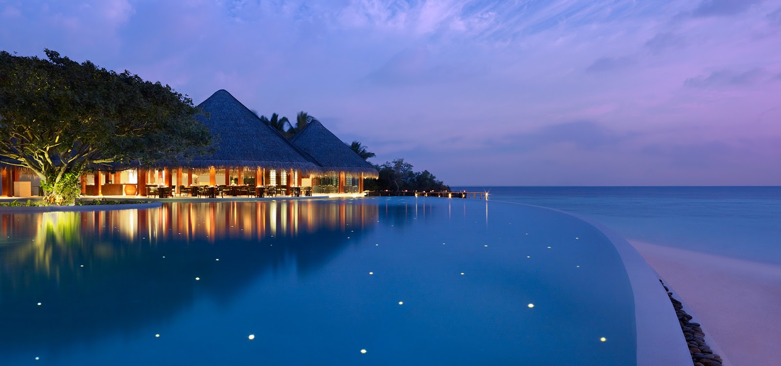
Description of a typical tropical resort


A resort of Maldives
A resort in the Maldives usually consists of an exclusive hotel on its own island, with a population composed entirely of tourists and labor, without inhabitants or local houses.

The islands developed for tourism usually have a size of 800 by 200 meters and are composed of sand and coral up to a maximum height of about 2 meters above the sea. In addition to its beach that surrounds the island, each island has its own "reef" that serves as a coral garden and a natural aquarium for scuba divers and divers. The shallow waters enclosed by the house reef also serve as a large natural pool and protect swimmers from the waves of the sea and strong tidal currents outside the reef of the house.


The buildings in a typical complex include rooms and suites reserved for the use of their guests, restaurants, cafes, shops, lounges, bars, nightclubs and diving schools. A part of the island also contains accommodation for staff and support services such as catering, electric generators, laundry and a sewer system. The stores on the island offer a wide range of products, such as souvenirs and artifacts. Most resorts offer a wide variety of activities such as aerobics, volleyball and table tennis.


Workers and tourism entrepreneurs.
Workers in the tourism industry are represented by the Maldives Tourism Employees Association (TEAM). TEAM argues that the 25,000 workers employed in the industry face poor conditions and have very low salaries (between US $ 80 and US $ 235 per month) given the cost of living . The employers' organization is known as the Maldives Association of the Tourism Industry.


Climate concerns
The economy of Maldives is very influenced by climate changes. The tourism sector may be affected by the increased likelihood of violent storms, damage to coral reefs and erosion of beaches, which is now more likely to occur due to rising seas.

As a result of climate change, Maldives is now facing the problem of the increasing discoloration of the seas and coral reefs. According to the World Bank, with "future levels of

Anchorage, Alaska


Alaska is a romantic and isolated destination, along with the beauty of nature in abundance. Anchorage offers many places to enjoy, such as the Glacier Bay National Park and Reserve, winter activities such as dog sledding, or taking a look at the spectacular northern lights or experiencing nature by choosing trails.

Anchorage (officially called the Municipality of Anchorage; Dena'ina: Dgheyaytnu) is a unified government municipality in the US state of Alaska. With an estimated 298,192 residents in 2016,  it is the most populous city in Alaska and contains more than 40 percent of the state's total population; Among the 50 states, only New York has a higher percentage of residents living in its most populated city. In total, the Anchorage metropolitan area, which combines Anchorage with the neighboring municipality of Matanuska-Susitna, had a population of 401,635 in 2016, representing more than half of the state's population. With 1,706 square miles of land area, the city is the fourth largest city by land in the United States and larger than the smallest state, Rhode Island, with 1,212 square miles.

The anchorage is located in the south-central part of Alaska, at the end of Cook Inlet, on a peninsula formed by Knik Arm to the north and Turnagain Arm to the south. [10] The city limits encompass 1,961.1 square miles (5,079.2 km2) encompassing the urban core, a joint military base, several peripheral communities and almost the entire Chugach State Park.

Due to its location, almost equidistant from New York City, Frankfurt and Tokyo, Anchorage is within 9 1/2 hours by air of almost 90% of the industrialized world. [13] For this reason, the Anchorage International Airport is a common refueling stop for many international cargo flights and houses a major FedEx hub, which the company considers a "critical part" of its global service network.

Anchorage has won the All-America City Award four times: in 1956, 1965, 1984-85 and 2002, by the National Civic League.  It has also been named by Kiplinger as the most tax-favored city in the United States.


History
Main articles: History of Anchorage, Alaska and Timeline of Anchorage, Alaska
The Russian presence in south-central Alaska was well established in the 19th century. In 1867, the Secretary of State of the United States, William H. Seward, negotiated an agreement to buy Alaska from Imperial Russia for $ 7.2 million, or approximately two cents per acre ($ 0.1 billion in 2016 dollars).  His political rivals mocked the agreement as "Seward's madness", "Seward's fridge" and "Walrussia". In 1888, gold was discovered along Turnagain's arm.


The town of the store (called "The White City" in the handwritten title) at Ship Creek, photographed by Alberta Pyatt on July 1, 1915.
Alaska became a territory of the United States in 1912. Anchorage, unlike any other large city in Alaska south of the Brooks Range, was not a fishing or mining camp. The area surrounding Anchorage lacks significant economic metallic minerals. A number of Dena'ina settlements existed throughout the Knik Arm for years. By 1911, the families of J. D. "Bud" Whitney and Jim St. Clair lived at the mouth of Ship Creek and were joined there by a young gamekeeper, Jack Brown, and his girlfriend, Nellie, in 1912.

The city grew from its chance choice as site, in 1914, under the direction of Frederick Mears, of a railroad construction port for the Alaska Engineering Commission. The area near the mouth of Ship Creek, where the railway headquarters was located, quickly became a tent city. A city site was plotted on higher ground south of the town than the tent, which is noticeable in the years after its order and rigidity compared to other sites in the city of Alaska. In 1915, territorial governor John Franklin Alexander Strong encouraged residents to change the name of the city to one that had "more importance and local associations."  In the summer of that year, residents voted to change the name of the city; A plurality of residents favored changing the name of the city to "City of Alaska". However, the territorial government finally refused to change the name of the city. Anchorage was incorporated on November 23, 1920.

The construction of the Alaska Railroad continued until its completion in 1923. The city's economy in the 1920s and 1930s focused on the railroad. Colonel Otto F. Ohlson, general manager of the railroad born in Sweden for almost two decades, became a symbol of the contempt of the residents due to the firm control he had over railway affairs, which by extension became control over aspects economic and others of life in Alaska.


Fourth Avenue in 1953, looking east from near I Street. Just ten years earlier, the commercial area showed

Siberia tourism


Siberia (Russian: Сибирь, Cibir) is a large and elaborate land area, which is almost complete in North Asia. This is the central and eastern part of Russia. By the year 1991 it used to be part of the Soviet Union. The area of ​​Siberia is 131 million square kilometers. For comparison, the area of ​​entire India is 32.8 million sq km, i.e. Siberia is almost four times more than India. Still, the weather and geography of Siberia are so strong that only 40 million people live here, which was the only state of Orissa in 2011.

Most of the straps in Eurasia (plain grassland) come from Siberia. Siberia extends from the Ural mountains in the west to the Pacific Ocean in the east and to the north-west ocean (Arctic Ocean) in the north. Its boundaries in the south are from Kazakhstan, Mongolia and China.


History
Approximately 25 to 50 million years ago (i.e. long before humans emerged on Earth), there were terrible volcanic eruptions in many areas of Siberia, which lasted for about one million years. It is believed that the breed of 90% of the organisms on Earth was killed due to them.  The Siberian Plateau's land is made of lava that is grown in the explosions.

Signs of human presence in Siberia are approximately 40,000 years old. Over time, many species have been settled or produced, including Yanat, Nanat, Avenk, Hun, Skithi and Uighur. In 13th century Mongolia was captured on Siberia, and in the 14th century an independent Siberian Sultanate was established. The Yakut settlers settled near the Bayak lake by the pressure of Mongols settled on the north. [2] Here, Mongols used to attack the West towards Russia by their bases. Russia's power began to grow in the 16th century and they started spreading to the east. The first merchant and ace-decked soldier arrived in Siberia, and the Russian army came behind them and started making bases and wood forts here. By the middle of the 17th century, Russian control had reached the Pacific Ocean. In 1709, the total Russian population of Siberia was 2,30,000.

By the end of the 19th century, Siberia remained an area of ​​backward and very low population. Here the royal government of Russia used to send his political prisoner, because there could not have been a runaway jail for the I-field spanning thousands of miles. In the period 1891-1916, the trans-Siberian railroad was connected, which added Siberia to Russia's industrial-full west part. Over time, the population of Siberia increased. The biggest economic business here was the removal of metals, coal and other substances from the earth.

In the Soviet era, major bases were built to keep prisoners here, called "gulag". [4] It is estimated that about 1.4 million people were sent to these Gulags. According to the Soviet policy, if any national community in the Soviet Union starts looking at suspicion in a part of the Soviet Union, sometimes more than five lakh prisoners have died in the slogan due to shortage of food during World War II. The whole communities were dispatched and sent to Siberia.


weather
Northern Siberia is a very cold area and the summer season only remains one month. Almost the entire population of Siberia lives in its southern part and lives near the trans-Siberian railroad. In this southern part, winters are hard (January's average temperature is -15 ° C) but at least 4 months of summer season is also where good crop can be grown. In July, the average temperature is 16 ° C and the daytime temperature reaches more than 20 ° C. Here the earth is of special type. It is called chornozem, which in Russian means "black soil" and it is very fertile.

The name of an administrative department of Siberia is the Sakhna republic, in which the lowest temperature in the city of Oyumyakon located at -71.2 ° C has been observed, on the basis of which it is the title of being the world's coldest city.


Population
The average density of population in Siberia is only 4 people per square kilometer. For the comparison, in the 2011 Census, the population of India in Bihar state was 1102 people per sq. Km. Most of the people here are Russians, or people of Ukrainian origin who have adopted the Russian identity. There are also people of about four million German origin in Siberia who have adopted Russian identity. Siberia Russia was formed only after the 17th century and the Russians had only entered this area. Before that, many tribes lived here, whose descendants still live here. These include Burayat, Tawai, Yakut and Siberian Tatar people. The number of burying and yakutas is more than four-four lakhs. There are also small populations of some other tribal castes, such as Ket, Avenk, Chukchi, Koryak, Yukagar, etc.

Northwest Territories of Canada


The Northwest Territories (NT or NWT, French: les Territoires du Nord-Ouest, TNO, Athabaskan languages: Denendeh, Inuinnaqtun: Nunatsiaq, Inuktitut: ᓄᓇᑦᓯᐊᖅ) is a federal territory of Canada. In an area of ​​land of approximately 1,144,000 km2 (442,000 square miles) and a population of 41,462 in 2011, it is the second largest and most populated of the three territories in northern Canada.  Its estimated population as of 2016 is 44,291. [5] Yellowknife became the territorial capital in 1967, following the recommendations of the Carrothers Commission.

The Northwest Territories, a part of the former Northwest Territory, entered the Canadian Confederation on July 15, 1870, but the current borders were formed on April 1, 1999, when the territory was subdivided to create Nunavut to the east, through the Nunavut Law and the Land Claims Agreement of Nunavut. [8] [9] Although Nunavut is primarily Arctic tundra, the Northwest Territories have a slightly warmer climate and are both boreal forest (taiga) and tundra, and their northernmost regions are part of the Canadian Arctic Archipelago.

The Northwest Territories are limited by the other two territories of Canada, Nunavut to the east and Yukon to the west, and by the provinces of British Columbia, Alberta and Saskatchewan to the south.


Etymology
The name is descriptive, adopted by the British government during the colonial era to indicate where it was in relation to Rupert's Land. It is shortened from the Northwest Territory (see History). In Inuktitut, the Northwest Territories are known as ᓄᓇᑦᓯᐊᖅ (Nunatsiaq), "beautiful land".

There was a discussion about changing the name of the Northwest Territories after the separation from Nunavut, possibly to a term of an aboriginal language. One proposal was "Denendeh" (a word from the Athabaskan language meaning "our land"), as defended by former Prime Minister Stephen Kakfwi, among others. One of the most popular proposals for a new name, one to name the territory "Bob", started as a joke, but for a while it was on top or near it in public opinion polls. [11] [12]

In the end, a survey conducted before the division showed that strong support was maintained to maintain the name "Territorios del Noroeste". This name could be said to have become more appropriate after the division than when the territories extended to the north-central and northeastern areas of Canada.


Geography
Located in northern Canada, the territory borders the other two territories of Canada, Yukon to the west and Nunavut to the east, and three provinces: British Columbia to the southwest, and Alberta and Saskatchewan to the south. You may encounter Manitoba in a quadripunto to the extreme southeast, although the surveys have not been completed. It has an area of ​​land of 1,183,085 km2 (456,792 square miles).

Geographical features include Great Bear Lake, the largest lake in its entirety within Canada, and Great Slave Lake, the deepest body of water in North America at 614 m (2,014 ft), as well as the Mackenzie River and the Nahanni canyons Reserve the National Park, a national park and a World Heritage Site by UNESCO. The territorial islands in the Canadian Arctic archipelago include Banks Island, Borden Island, Prince Patrick Island and parts of Victoria Island and Melville Island. Its highest point is Mount Nirvana, near the Yukon border, at an elevation of 2,773 m (9,098 ft).

History
The current territory came under the authority of the government in July 1870, after the Hudson Bay Company transferred the Land of Rupert and the Northwest Territory to the British Crown, which subsequently transferred them to the Dominion of Canada, giving it the Northwest name. Territories. This immense region comprised all of Canada today, except that which was included among the first signatories of the Canadian Confederation, namely British Columbia, the first forms of present-day Ontario and Quebec (covering the Great Lakes coast, the San Lorenzo river). valley and the southern third of Quebec, the Maritimes (NS, PEI and NB), Newfoundland, the Labrador coast and the Arctic islands, except the southern half of Baffin Island (the Arctic islands remained under direct British claim until 1880) .

After the transfer of 1870, some of the Northwest Territories were reduced. The province of Manitoba was created on July 15, 1870, first in a small square area around Winnipeg, and then expanded in 1881 to a larger rectangular region that makes up the south of the modern province. When British Columbia joined the Confederation on July 20, 1871, it had already received (1866) the portion of the Northwest Territory south of 60 degrees north and west of 120 degrees west

Thursday, January 17, 2019

Galápagos Islands


Las Islas Galápagos (nombre oficial: Archipiélago de Colón, otro nombre en español: Las Islas Galápagos, parte de la pronunciación en español de la República del Ecuador, son un archipiélago de islas volcánicas distribuidas a ambos lados del ecuador en el Océano Pacífico que rodea el centro del Hemisferio occidental, 906 km (563 mi) al oeste del Ecuador continental. Las islas son conocidas por su gran número de especies endémicas y fueron estudiadas por Charles Darwin durante el segundo viaje de HMS Beagle. Sus observaciones y colecciones contribuyeron al inicio de la teoría de Darwin. De la evolución mediante la selección natural.

Las islas Galápagos y sus aguas circundantes forman la Provincia de Galápagos de Ecuador, el Parque Nacional Galápagos y la Reserva Marina de Galápagos. El idioma principal en las islas es el español. Las islas tienen una población de poco más de 25,000.


La primera visita registrada a las islas ocurrió por casualidad en 1535, cuando Fray Tomás de Berlanga, el obispo de Panamá, se sorprendió con esta tierra por descubrir durante un viaje a Perú para arbitrar en una disputa entre Francisco Pizarro y Diego de Almagro. [2 ] De Berlanga finalmente regresó al Imperio español y describió las condiciones de las islas y los animales que las habitaban. El grupo de islas fue mostrado y nombrado en el atlas de Abraham Ortelius publicado en 1570. El primer mapa crudo de las islas fue hecho en 1684 por el bucanero Ambrose Cowley, quien nombró las islas individuales por algunos de sus compañeros piratas o por la realeza británica y los nobles. . Estos nombres se usaron en las cartas de navegación autorizadas de las islas preparadas durante la encuesta de Beagle con el capitán Robert FitzRoy, y en el popular libro de Darwin El viaje del beagle. La nueva República del Ecuador tomó las islas de propiedad española en 1832, y posteriormente les dio nombres oficiales en español. [3] Los nombres más antiguos se mantuvieron en uso en publicaciones en inglés, incluidas las Encantadas de 1854 de Herman Melville.


Geología
El volcanismo ha sido continuo en las Islas Galápagos por al menos 20 millones de años, y quizás incluso más. El penacho del manto debajo de la placa de Nazca en movimiento hacia el este (51 km / myr) ha dado lugar a una plataforma de 3 kilómetros de espesor debajo de la cadena de islas y los montes submarinos. Además del archipiélago de Galápagos, otras características tectónicas clave en la región incluyen la Provincia Volcánica del Norte de Galápagos entre el archipiélago y el Centro de Extensión de Galápagos (GSC) a 200 km al norte en el límite de la Placa de Nazca y la Placa de Cocos. Este centro en expansión se trunca en la subida del Pacífico oriental en el oeste y está rodeado por Cocos Ridge y Carnegie Ridge en el este. Además, el hotspot de Galápagos se encuentra en el límite norte de la Provincia de la Velocidad de Alta Cizalla Grande del Pacífico, mientras que el Hotspot de Pascua se encuentra en el límite sur.


El archipiélago de Galápagos se caracteriza por numerosos volcanes contemporáneos, algunos con fuentes de magma de pluma, otros de la astenosfera, posiblemente debido a la corteza oceánica joven y delgada. El GSC causó debilidades estructurales en esta delgada litosfera que llevó a las erupciones que forman la Plataforma Galápagos. Fernandina e Isabela en particular están alineadas a lo largo de estas debilidades. Al carecer de una zona de ruptura bien definida, las islas tienen una alta tasa de inflación antes de la erupción. Sierra Negra en la isla Isabela experimentó una elevación de 240 cm entre 1992 y 1998, la erupción más reciente en 2005, mientras que Fernandina en la isla Fernandina indicó una elevación de 90 cm, la erupción más reciente en 2009. Alcedo en la isla Isabela tuvo una elevación superior a 90 cm, la erupción más reciente en 1993. Las características adicionales del archipiélago de Galápagos son una separación más cercana de los volcanes, tamaños de volcanes más pequeños y calderas más grandes. Por ejemplo, la isla Isabela incluye 6 volcanes principales, Ecuador, Wolf, Darwin, Alcedo, Sierra Negraa y Cerro Azul, con las erupciones más recientes desde 1813 hasta 2008. Las islas vecinas de Santiago y Fernandina hicieron erupción por última vez en 1906 y 2009, respectivamente. En general, los 9 volcanes activos en el archipiélago han entrado en erupción 24 veces entre 1961 y 2011. La forma de estos volcanes es la de un "tazón de sopa volcado" en oposición a la "placa de platillo volcada" de las islas de Hawai. La forma de las Galápagos se debe al patrón de fisura radial y circunferencial, radial en los flancos, pero circunferencial cerca de las cumbres de la caldera. Son las fisuras circunferenciales las que dan lugar a pilas de flujos de lava cortos.


Los volcanes en el extremo oeste del archipiélago son en general, más altos, más jóvenes, tienen calderas bien desarrolladas, y en su mayoría están compuestos de basalto toleiítico, mientras que los del este son más cortos, más viejos, carecen de calderas y tienen una composición más diversa. Las edades de las islas, de oeste a este son 0.05 Ma para Fernandina, 0.65 Ma para Isabela, 1.10 Ma para Santiago, 1.7 Ma para Santa Cruz, 2.90 Ma para Santa Fe y 3.2 Ma para San Cristóbal. Las calderas en Sierra Negra y Alcedo.

Tourism in Papua New Guinea


Tourism in Papua New Guinea is an incipient industry, but there are attractions for the potential visitor that include culture, markets, festivals, diving, surfing, hiking, fishing and unique flora and fauna. Papua New Guinea receives an increasing number of visitors each year, with approximately
184,000 international arrivals in 2015.


History
In April of 1883, James Burns and Robert Philp began a commercial partnership, originally called "Burns Philp & Company Limited". [2] They were the first company to offer tourism to New Guinea, in 1884, announcing the 'Excursion Trip to New Guinea'. [3] This consisted of a five-week trip from the Island of Thursday and has been described as the "official start of tourist cruises in the South Pacific." [4] The company later published a book entitled Picturesque Voyage.

In 1914, the Department of Tourism of Burns Philp was established on advertising tours in Lord Howe and on the island of Norfolk. The acquisition of the Hotel Port Moresby happened the same year, and the Hotel Papua was bought some years later. Burns Philp "maintained a close monopoly on passenger services to Melanesia until the outbreak of the war in the Pacific." [5] In the war, the British government took over part of the Burns Philp fleet and the Macdui ship sank in Port Moresby in 1942 as their first trip as a troop carrier.

Attractions

Culture
Main article: Culture of Papua New Guinea.
The culture of Papua New Guinea is very diverse, as it implies the existence of more than 800 languages ​​in the country. The styles of cultural expression (size, dance, song, ornamentation, architecture and more) vary enormously throughout the country.

Festivals

Festival of Hiri Moale
Public festivals that are open to tourists include the Coffee Festival in Goroka - May, National Mask Festival in Rabaul-July, Monte Hagen Show - August, Goroka Show - September, Hiri Moale Festival in Port Moresby - September, Morobe show in Lae - October, Kundu and Canoe Festival in Alotau - November.

The markets
The markets are a great attraction for tourists. Along with local foods, handicrafts are often on display and can be purchased at reasonable prices. Some of the items on display are traditional carvings and beads, traditional and contemporary paintings on canvas and traditionally woven baskets and serving trays. The larger and more tourism-oriented markets are usually held once a month in the larger cities.

Diving
PNG is possibly one of the best diving destinations in the world, with one of the healthiest coral reef systems on the planet. In addition to a large number of reef sites, there are also numerous ships and aircraft wrecked from World War II, which offer a lot of diving opportunities in shipwrecks. Some of the best places to dive are in West New Britain / Kimbe Bay, Kavieng, Madang, Alotau, Tufi and East New Britain / Rabaul. The capital, Port Moresby, also offers excellent diving.

Many of the dive sites are easily accessible by boat for a day trip, and there are many more remote sites that you can dive from one of the many accommodations that are offered locally.


Surfing
You can surf all year round. The southern side of PNG includes places like Hula Beach (100 km from Port Moresby), Milne Bay, Bougainville and East New Britain, which can be reached from June to September. In the north of the PNG surf season is from mid-October to the end of April. There are excellent surf locations that include Madang, Wewak and Kavieng, with the best and most consistent waves found in Vanimo.

Mountain hiking
The most famous walking trail in Papua New Guinea is Kokoda Track, the site of a famous World War II battle between Australia and Japan. Another popular hike is to climb Mount Wilhelm, the highest mountain in Papua New Guinea. There are many more walking tracks, including the Bulldog and Black Cat tracks.

Security
Many countries have issued travel warnings to their citizens wishing to visit Papua New Guinea, due to their high level of violent crime, the slow response times of the police and the poor record of human rights.

Foreign citizens in Papua New Guinea have become tempting targets for criminals, especially those who visit richer countries are more likely to become victims of violence and crime. Lonely foreign women are generally advised not to travel without an escort in Port Moresby and parts of the Highlands region due to the high risks of unwanted harassment and sexual assault. In general, countries of origin advise travelers to seek updated information on

Wednesday, January 16, 2019

Tourism in Seychelles


Tourism is the most important non-governmental sector of the economy of Seychelles. Approximately 15 percent of the formal labor force is directly employed in tourism, and employment in construction, banking, transportation and other activities is closely linked to the tourism industry. Tourists enjoy the coral beaches of Seychelles and the opportunities for water sports. The wildlife in the archipelago is also a major attraction.


History
The tourism industry was born with the completion of the Seychelles International Airport in 1971, rapidly advancing to a level of 77,400 arrivals in 1979. After declining in the early 1980s, growth was restored by introducing casinos, vigorous and more competitive advertising campaigns After a decline to 90,050 in 1991 due to the Persian Gulf War, the number of visitors increased to more than 116,000 in 1993. In 1991, France was the main source of tourists, followed by the United Kingdom, Germany, Italy and South Africa. Europe provided 80 percent of the total tourists and Africa, mostly South Africa and Reunion, most of the rest. European tourists are considered the most lucrative in terms of length of stay and expenditure per capita.

Under the 1990-94 development plan, which emphasizes that the growth of tourism should not be at the expense of the environment, the number of beds on the islands of Mahé, Praslin and La Digue should be limited to 4,000. The increase in total capacity will be achieved by developing the outer islands. To avoid future threats to the natural attractions of the islands, 150,000 tourists per year are considered the maximum ceiling. The higher cost of accommodation and travel, deficiencies in services and maintenance of facilities, and a limited range of detours, harm Seychelles to attract tourists at the expense of other Indian Ocean tourist destinations


Statistics
The direct contribution of the tourism sector to GDP was estimated at 50 percent, and provides about 70 percent of total foreign exchange earnings. Although it is difficult to measure, the import content of tourism expenditures is high, so net tourism revenues are significantly lower. [2] In 2000 there were 130,046 tourist arrivals, including more than 104,000 from Europe. In the same year, Seychelles had 2,479 hotel rooms with 5,010 full beds up to 52% capacity. The income of tourists was US $ 112 million in 1999. In 2002, the US Department of State. UU He estimated the average daily cost of staying in Seychelles at $ 246 per day. According to the National Bureau of Statistics, 230,272 tourists visited Seychelles in 2013 compared to 208,034 in 2012

Gobi Desert, China and Mongolia


Located in Gobi Desert, China and Mongolia. It is one of the largest desert desert in the world. Gobi is one of the cold deserts of the world, where the temperature goes down from minus 40 degrees. The Gobi Desert spreads on most of the Mongolia in the Asia-continent. This desert is one of the most deserts of the world. 'Gobi' is a Mongolian word, which means 'waterless place'. Nowadays Gobi desert is a deserts, but in ancient times it was not like this. Rich Indian settlements were settled between this region. The Gobi Desert extends from the eastern hills of Pamir in the west to the Khingan ranges in the east and from Altai, Khangai and Yablonoi ranges in the north to the Altai and Nanshan hills in the south. The western part of this desert is only a part of the Tarim Basin.

This is the fifth largest in the world and Asia's largest desert. Like the Sahara Desert, this desert can also be divided into three parts - 1. Talak Maken Desert 2. Alshan Desert 3. Muas or Ordis Desert


Much of the Gobi desert is rocky and not sandy. Here the climate of the desert changes rapidly. Not only does the temperature change throughout the year, but it also changes in temperature within 24 hours. The average rainfall in the Gobi desert is 50 to 100 mm. is. Most of the rainfall here is in the summer season. Most of the rivers in the desert flow in the rainy season. Therefore, only in the rainy season, water remains in the river. Water streams from adjacent mountains fall into the dry land of the desert. Here the plants named Saxol, which have compostious and dry resistant properties, are found in abundance. Almost without leaf leaves, this plant rises in areas where the sand is unstable. Due to this special quality, this plant is helpful in preventing soil erosion. Gobi Desert is considered as the 'Beckittarian camel', which has two holes. Kachhu Jagelli variety asses are also found here. The special bears of desert in the world are found in this desert. The species of these bears 'fun' or 'Gobi' has reached the brink of extinction. In addition, wild horses, squirrels, and small reefs are also found here. One of the major desert expanses of the world, the desert of Gobi, which extends approximately 600 miles from north to south and about 1000 miles east to west, exists as a shallow trough between Tibet and Altai ranges. Its natural landscape is similar to the sloping ground, with mountain elevations around it. With the prevailing erosion and corrosive actions, this desert is famous for its distinctive rhythm. The water mark on the foothills of the dried rivers and the height of the lakes, is the evidence of change in the climate here. Civilization Relics The ancient ruins of different civilizations are also found in this desert. Here the heat gets much faster and the average temperature in the summer is 45 ° to 65 ° C. And winter heat is 15 ° C Stays till. Here snowflakes and stormy storms sometimes come. Here the grass and prickly shrubs are found mainly in the vegetation. There is often lack of water here. Between 10 miles and 40 miles of wells are found on caravan routes. Animals In the eastern part of this desert where there is some rainfall from the southwest monsoon, there is a small farming area, and sheep, goats and other animals are reared. Sheep goats are also reared in North-West Frontier regions. There are some forests in the far north. There are Chinese settlements in the valleys of Orakhan and its tributaries in the north. The population is very sparse. Mongol is the main caste here. Tribal people in the grasslands of the north and the south, who live the life of nomads. Most of the caravan routes are from east to west, on which Chinese traders trade on clothes, shoes, tea, tobacco, wool, leather and leather etc. Remnants of Indian Culture In the Gobi Desert, archaeological excavations by 'Sir Oxel Stone' have been found in the remains of Buddhist stupas, monasteries, Buddhist and Hindu deities, many manuscripts and many articles in Indian languages ​​and epics. Surrounding these residues, Sar-Aurl started to experience that he was roaming in an ancient village of Punjab. In the 7th century, the famous Chinese traveler, Hwy Tsang, came to India only through the Gobi Desert and then returned to China. He showed the preference of Buddhism and Indian culture in this region. As the desert grew in this region, the center of Indian culture became extinct here.


It is the fifth largest desert in the world, spread across 1, 623 square kilometers. It is surrounded by Altai mountain and Mongolia's Stepei and pasture, in the north, the Ghanshu's corridor in the south-west and the Tibetan Plateau and the south-eastern region of China's northern region. It is also known for many types of fossils and rare animals. Gobi Desert has been a part of the great Mongol empire in the past and has been the area of ​​many important cities associated with Silk Road. It is built on the basis of ecological and geographical areas due to a variety of distinct changes in desert climate and topography. Gobi desert is on the other side of the Himalayas, of which

Sahara Desert For Tourist


Sahara (Arabic: "The Largest Desert") is the world's largest hot desert. The name Sahara is derived from the Arabic word Sahra , which means desert.  It is the Atlantic in the northern part of Africa Extends up to 5,600 kilometers from the ocean to the Red Sea, extending from Sudan to the north and Atlas Mountains south to 1,300 kilometers, including some coastal areas of the Mediterranean Sea. In this, it is almost equal to Europe and more than double the area of ​​India, this is an expanse of the desert in Mali, Morocco, Muttania, Algeria, Tunisia, Libya, Niger, Chad, Sudan and Egypt. It is a semi-arid tropical savanna region, which separates the Sahara from the rest of Africa.

Sahara is a low desert plateau whose average height is 300 meters. The intermittent history of this tropical desert is about three million years old. [3] Here are some low volcanic mountains, which include Hogar of Algeria and Tibesti Mountain of Libya. Located on the Tibesti Mountain, the Eimi Kuni volcano is the highest point of Sahara, whose height is 3,415 meters. The dunes and ravens of the vast sand formed with the wind make its normal geomorphic nature. In the west of the Sahara desert, large sand sand mounds are found in the region of the Maricinia. Some sand dunes can reach up to 180 meters (600 feet) in height. [4] In some parts of the Sahara, some of the green herbs are found due to irrigation facilities by well, river, or waterfall. Kufara, Tuyet, Weddale, Tininkukku, Lajuf are the chief herbs of Sahara. There are dry valleys of the rivers, which are called Wadi. Here lakes of lake water are found.


The climate of the Sahara desert is dry and odd. Here, both daily temperature and annual temperature are high. There is a severe heat in the day and severe cold in the night. The temperature reaches 580 ° C in the day and the temperature goes down even below freezing point in the night. A recent research has shown that Africa's Sahara region has been transformed into the largest desert of the world almost two and a half thousand years due to continuous decrease of greenery. The northern areas of Africa were filled with greenery 6,000 years ago. Apart from this, there were also many lakes. Most of the evidence giving a detailed account of this physical change has also been destroyed. These studies were done on Lake Yoa in Chad. According to the scientist Stefan Kroplin, Sahara took considerable time to become the desert; according to the old theories and beliefs, greenery decreased rapidly in the last five and a half thousand years, and this desert was born. In the year 2000, Dr. Peter Maikolle's study of Columbia University supports old recognition.

Harmattam winds move from north-east direction in the Sahara desert. They are hot and dry. In the coastal areas of Guinea, these winds are popular in the name of Dr. Vayu because they provide relief to the residents of this region by the humid weather. Apart from this, in the months of May and September, in the areas of northern and northeastern Sudan, in the afternoon, there are dust storms especially in the adjacent areas of the capital Khartoum. Due to these, it also becomes very less visible. These winds called Habubu bring heavy rains along with thunder and thunderstorms.


Geography
The top image shows the Oasis on the surface of the Sahara. Below (use of radar) is a rock layer below, which reveals black channels filled with a type of tube of an ancient river, which once used Oasis feeds. ]] Sahara covers a large portion of Algeria, Chad, Egypt, Libya, Mali, Mauritania, Niger, Western Sahara, Sudan and Tunisia. It includes 9 million square kilometers (3,500,000 square miles), which is the sum of 31% of Africa. If all areas were covered with an average annual rainfall of less than 250 mm, then Sahara would be 11 million square kilometers (4,200,000 square miles). This African is one of the three distinct geographical provinces of the geographical division on a large scale.

Sahara mainly make rocky Hamada (stone plateaus), arag (sand areas - large areas with sand dunes) only make a slight part, but many sand tiny is 180 meters (590 feet) high. Air or rare rainfall characteristics of the desert: shaped sand dunes, dunes fields, sand ocean, stone plateau, gravel grounds, dry valleys (wadi), dry lakes (voice), and salt flats (shots or chats) Are there. Unusual landforms include ranch structure in Mauritania

Many grow deeply disintegrated mountains, many volcanic eras, mountain ranges from Aghangaar, Saharan Atlas, Tibetan Mountains, Adar des Ifras and Red Sea hills. The highest peak in Sahara is a shield volcano, Emi Kossi in the Tibesti range of Northern Chad.

Central Sahara is hyperarid, with rare vegetation. To the north and south of the desert, with mountainous terrain, along with trees and tall shrubs, where moisture collects, there are areas of rare grazing and desert springs. In the central, hyperarid area, there are several subdivisions of the Great Desert: Tanezoft, Tenera, Libyan Desert, Eastern Desert, Nubian Desert and others. These extremely dry areas do not get rain for many years.

In the north, Sahara skirts in the Mediterranean Sea and parts of Libya in Egypt, but in Cyrenica and Magreb, Sahara has a Mediterranean forest,

Tourism Antarctica


Tourism in Antarctica started by the sea in the sixties. Air flights from Antarctica began in the 1970s with tourist aircraft flights from Australia and New Zealand, and resumed in the 1990s. The tour season (summer) lasts from November to March. Most of the estimated 14,762 visitors to Antarctica in 1999-2000 were on maritime cruises. During the 2009-2010 tourist season, more than 37,000 people visited Antarctica.
Cruises by the sea

The expedition ship National Geographic Explorer
During the 1920s, a mail boat from the Falkland Islands, the SS Fleurus, made annual trips to the South Shetland Islands and the South Orkney Islands to serve the whaling and sealing stations. It carried a small number of commercial passengers and commercialized round-trip "tourist tickets"; These were probably the first commercial tourists to sail to Antarctica. [3]

The modern cruise expedition was started by Lars-Eric Lindblad; In 1969, he launched the MS Lindblad Explorer, a specially designed liner. [4] Many of the maritime cruises depart from Ushuaia in Argentina. Ocean cruises generally last between 10 days and 3 weeks and costs start at around US $ 6,000 per person for shared hosting booths.


There are limited maritime cruises to the regions of Antarctica in the Ross Sea and East Antarctica (Commonwealth Bay). The travel company of the New Zealand expedition, Heritage Expeditions, operates its own polar research vessel reinforced with ice, the "Spirit of Enderby", in these regions several times a year.

Occasionally, very large cruises have visited Antarctica with more than 950 people. These vessels are usually cruise ships and do not offer landings. However, in 2009, new regulations were implemented that prevented large vessels from operating in Antarctic waters due to their heavier fuels. Normally, boats can only disembark 100 people at a time and those that transport more than 500 people can not disembark.

Panoramic flights

A Basler BT-67 owned by the Antarctic Logistics Center International and used for tourist flights in Antarctica, at the South Pole in December 2009.
Most of the scenic flights to Antarctica have been organized from Australia and New Zealand, and airlines from both countries started flights in February 1977. Most flights are simple return trips, and in no case have they landed on the Antarctica.

The first panoramic flight of Air New Zealand took place on February 15, 1977 and was followed by five more that year, then four in 1978 and 1979. The flights were operated with McDonnell-Douglas DC-10 and left Auckland, flying over the Ross Island for McMurdo Sound before returning to Auckland with a fuel stop in Christchurch. Subsequent flights flew in the middle of the Sound and on the Scott Base instead of on the Ross Island, as the plane could descend to a low altitude to provide better visibility for the passengers [note 1]. Many flights took experienced Antarctic investigators as guides, including on at least one occasion to Sir Edmund Hillary, and lasted approximately 12 hours with approximately four of them on or near the Antarctic continent. Air New Zealand canceled and never resumed its Antarctic flight program after the disaster of the TE901 [note 2], where a route planning error caused the aircraft to crash into Mount Erebus on November 28, 1979 with the loss of the aircraft. 257 lives on board.


Qantas operated his first Antarctic flight on February 13, 1977, a letter organized by businessman Dick Smith Dick Smith. By 1979, twenty-seven flights had transported more than 7,000 passengers. The majority used Boeing 747-200B and flew from Sydney, Melbourne or Perth on one of two "ice" routes. One was along the coast of George V Land to the French base at Adele Land and then back on the Magnetic South Pole. The other went through Oates Land and northern Victoria Land to Cape Washington in the Ross Unit. In 1977, a flight doubled Air New Zealand routes and overflew McMurdo Sound and Mount Erebus. Some shorter flights from Melbourne were also operated by Boeing 707s.  Qantas also canceled its Antarctic program after the TE901 disaster, but finally resumed it in 1994, and continues to operate charter flights in the summer from Sydney, Perth and Melbourne to this day with the Boeing 747-400.

There were also previous panoramic flights, including some from Chile in 1958.

Of yachts
There were private yacht trips in the Southern Ocean since the late 1960s, with some tours of Antarctica, for example. by David Henry Lewis in 1972. 

Amazon Rain Forest in the world


The Amazon Rainforest (Portuguese: Amazonian Rainforest or Amazônia, Spanish: Amazonian Rainforest, Amazonia or usually Amazonia, French: Forêt amazonienne, Dutch: Amazoneregenwoud), also known in English as Amazonia or Amazon Jungle, is a broadleaf rain forest in the Amazon. Biome that covers most of the Amazon basin of South America. This basin covers 7,000,000 km2 (2,700,000 square miles), of which 5,500,000 km2 (2,100,000 square miles) are covered by tropical rainforest. This region includes territory belonging to nine nations. Most of the forest is within Brazil, with 60% of the rain forest, followed by Peru with 13%, Colombia with 10% and with smaller amounts in Venezuela, Ecuador, Bolivia, Guyana, Suriname and French Guiana . States or departments in four nations contain "Amazons" in their names. The Amazon represents more than half of the remaining rainforests on the planet, [1] and comprises the largest and most biodiverse stretch of tropical rainforest in the world, with an estimated 390 billion individual trees divided into 16,000 species


History

natural

The rain forest was probably formed during the Eocene era. It appeared after a global reduction in tropical temperatures when the Atlantic Ocean had widened enough to provide a warm and humid climate to the Amazon basin. The rainforest has existed for at least 55 million years, and most of the region remained free of savanna-type biomes at least until the current ice age, when the climate was drier and the savannah was more widespread. [Four. Five]

After the Cretaceous-Paleogene extinction event, the extinction of the dinosaurs and the more humid climate may have allowed the rainforest to spread throughout the continent. From 66 to 34 Mya, the tropical forest extended south to 45 °. Climatic fluctuations during the last 34 million years have allowed savanna regions to expand to the tropics. During the Oligocene, for example, the tropical forest encompassed a relatively narrow band. It expanded again during the Middle Miocene, and then retreated to a mostly interior formation at the last glacial peak. [6] However, the rainforest still managed to thrive during these glacial periods, allowing the survival and evolution of a wide diversity of species.

During the Middle Eocene, it is believed that the drainage basin of the Amazon was divided along the middle of the continent by the Purus Arch. The water on the east side flowed to the Atlantic, while to the west the water flowed into the Pacific through the Amazon Basin. However, as the mountains of the Andes rose, a large basin enclosing a lake was created; now known as the Solimões Basin. In the last 5-10 million years, this accumulation of water crossed the Purus Arch and joined the flow from the east to the Atlantic.


There is evidence that there have been significant changes in the vegetation of the Amazon rainforest in the last 21,000 years through the last glacial maximum (LGM) and the subsequent deglaciation. Analyzes of the sediment deposits of the Paleolac of the Amazon basin and of the Amazonian range indicate that rainfall in the basin during the LGM was lower than in the present, and this was almost certainly associated with reduced coverage of humid tropical vegetation in the basin.  There is a debate, however, about how extensive this reduction was. Some scientists argue that the rainforest was reduced to small isolated refuges separated by open forests and pastures;  other scientists argue that the rainforest remained largely intact but extended less to the north, south and east than is seen today. 12] This debate has been difficult to resolve because the practical limitations of working in the rainforest mean that data sampling deviates from the center of the Amazon basin, and both explanations are reasonably well supported by the available data.


The dust of the Sahara desert swept by the wind to the Amazon
More than 56% of the dust that fertilizes the Amazon rainforest comes from the Bodélé depression in northern Chad in the Sahara desert. The powder contains phosphorus, important for the growth of plants. The annual dust of the Sahara replaces the equivalent amount of phosphorus that is washed annually in the soil of the Amazon rain and flood.  Up to 50 million tons of Saharan dust are transported per year through the Atlantic Ocean.  NASA video.


NASA's CALIPSO satellite has measured the amount of dust transported by the wind from the Sahara to the Amazon: an average of 182 million

demo

sdfdg hhf j j jgjgj 

Thursday, January 10, 2019

Taj Mahal, Agra city of India


Taj Mahal is a World Heritage Tomb located in Agra city of India. It was built by the Mughal emperor Shah Jahan, in memory of his wife Mumtaz Mahal.
Tajmahal is an excellent example of Mughal architecture. Its architectural style is a unique combination of Persian, Turk, Indian and Islamic architectural components. In 1983, the Taj Mahal became the UNESCO World Heritage Site. Along with this, it was described as one of the finest human works, receiving universal acclaim of World Heritage. The Taj Mahal has also been declared the gem of Islamic art of India. Generally, the cobblestone of the sawmills is not made like the buildings covered with large ribs and it is covered with a white dome and a tile size of a marble in [2]. The tomb built at the center introduces the combination of beauty in its architectural superiority. The highlight of the structure of the Taj Mahal building is that it is completely symmetrical. Its construction was almost completed around 1648. [1] Ustad Ahmad Lahauri is often regarded as its chief architect.

Architectural art


Mausoleum
Taj Mahal is the focal point, the white marmalade built on a square foundation basis. This is a symmetrical building, in which an Evan is a vast curved gate (arch-shaped). A large dome is adorned above this building. Like most Mughal tomb, its original components are from Persian origin.

basic premise
Its basic base is a large multi-orbital structure. The main chamber is cuboid, each of which is 55 meters (see: Floor Map, Right). On the long edges, there is a heavy pistachio, or room chamber with an arched ceiling. It is covered with a raised arched balcony.

Main arches
On the either side of the main arches, on the one side, in the second style, two-two extra pistachars are made. In this style, two or two pistols (one above the other) are made on four edges of the chamber. This composition is completely symmetrical on each side of the building, which makes this building octagon rather than square, but due to the four sides of the corner being quite small from the other four edges, it would be appropriate to call it square. Four towers around the tomb seem to be building in the four corners of the base basin, in a framework of the building. In the main room there are fake tombs of Mumtaz Mahal and Shahjahan. They are very ornate, and they are actually located on the bottom floor.

The dome
The most beautiful part of the dome (see left) on the tomb is the most beautiful part of it. Its height is approximately 35 meters, equal to the base of the building and it is located on a cylindrical basis of 7 meters high. It is also called a dome of onion size (also called guava shape) on its size. Its peak is embellished with an inverted lotus. It gives insertion to the edges of the dome on the summit.

Umbrellas
The shape of the dome gets more force from its four small dome (see right) at its four edges. The umbrella's dome, the main dome-shaped copies, is only the difference of the measure. Their column headings are open on the terrace for the arrangement of internal lighting. Highly decorated bouquets of the marble, emphasize the height of the dome. Along with the main dome, on the umbrellas and bouquets, the Kamarkar peaks. On the peak of the domes and umbrellas, the famous Persian and Hindu architectural masterpiece of art is decorated in a metallic vase kiritupurup.

Crown pinnacle
On the crown of the main dome is the Kalash (see right). This peak kalash was golden till early 1800 AD and now it is made of bronze. This is a unifying combination of components of Kirt-Kalash Persian and Hindu Vaastu art. It is also found on the summit of Hindu temples. The moon is made on this urn, whose tip points to heaven. Due to their planning, the notes of the moon and the urn make together the shape of a trident, which is the sign of Hindu Lord Shiva. [4]

Towers

Unique view of crown with sunset sun
Four huge towers (see left) are located on the four corners of the main base. It is every 40 meters high. These minarets show the symmetrical tendency of the Taj Mahal's texture. These minarets are built just like the minarets to be set up in the mosque. Each minaret is divided into three equal parts by two shades. The last balcony on top of the tower, which has a umbrella similar to the main building. These are also the Kamarakaar shape and the crown kalash. There is a special thing in these minarets, it has a slight tilt towards the outside, so that in the event of falling, it falls on the outside, and the main building can not get any damage.

Outdoor decoration

Calligraphy on the big pistachio
Exterior decoration of Taj Mahal is the finest example of Mughal architecture. As soon as the surface area changes, the area of ​​large pistach is more than the smallest and its ornamentation also changes in the same proportion. The adornment components are manufactured by rubbing or grueling or by carving and gemstones. Islam has fully adhered to the prohibition of humanitarianism. Adornment is done only with calligraphy, formless, geometrical or plant motif.

The calligraphy found in Taj Mahal is from the Florida Thuluth script. They are created by Persian clerk Amant Khan. The calligraphy Jasper has been rooted in the white marble panels. The work done on the Sanataph of Sangramarir is extremely negligible, soft and fine. Height has been taken care of. High panels have been written in the same proportion, so that they do not seem to be tired of looking downwards. The entire area has been used for the rectangles of Quran, ornamentation. Recent shows

Red Fort, Delhi


The Red Fort or Red Fort, located in the historic, captured and old area of ​​Delhi, is made of red sandstone. The fort was built by the fifth Mughal Badshah Shah Jahan. This fort is called "Red Fort" due to the red color of its walls. This historic fortress was selected by a UNESCO World Heritage site in 2007.

History

The city of Red Fort and Shahjahanabad, erected by the Mughal Emperor Shah Jahan, was erected in 1639. The layout of the Red Fort was redone to be integrated with the Fort of Salimgarh. This fort and palace have been an important focal point for the medieval city of Shahjahanabad. The planning, the arrangement and the beauty of the Red Fort is the peculiarity of Mughal creativity, which reached its maximum elevation during the time of Shah Jahan. After the construction of this fort, Shah Jahan carried out many development work. Many important aspects of the development were made by Aurangzeb and the last Mughal rulers. Many basic changes in the entire configuration were made after the first struggle for independence in 1857 in the British period. During the British period, this fort was used mainly in the form of cantonment. Rather, after independence, many of its important parts remained under army control until 2003.

The Red Fort was the palace of Shahjahanabad, the new capital of the Mughal Emperor Shah Jahan. This was the seventh Muslim city in the city of Delhi. He changed his capital from Agra to Delhi, to increase the prestige of his government, as well as to give new opportunities to the ambition to create new ones. There was also his main interest in this.

This fort is located on the banks of the Yamuna River as well as the Taj Mahal and Agra Fort. The water of the same river surrounded this fort and filled the trench. Its northeast side wall was attached to an ancient fortress, which is also known as the Salimgarh fortress. The fort of Salimgarh was built by Islam Shah Suri in 1546. The construction of the Red Fort was completed in 1638 and completed in 1648. But according to some opinions, it describes an ancient fort and city of Lalkot, which was captured by Shah Jahan and built this strong. King Lalkot, Prithviraj Chauhan, was the capital in the last phase of the 12th century.

On March 11, 1783, the Sikhs entered the Red Fort and captured Diwan-i-Aam. The Mughal chiefs surrendered to the city for their fellow Sikhs. This work was carried out under the command of Sardar Baghel Singh Dhaliwal of Karor Singhia Misal.


Measurement risk
Lalkila is located at the eastern end of Salimgarh. It has its name due to the walls and red sandstone wall. This makes four candles. This wall is 1.5 miles long (2.5 km) and is 60 feet (16 m) and 110 feet (35 m) high, from the edge of the river. It is known by the strength of its measurement, that its plan has been made using a square grid (square door) of 82 m.

The scheme of the Red Fort was completely completed and subsequent changes have not allowed any change in the origin of its plan. In the eighteenth century, some of its parts were damaged by thieves and invaders. After the first freedom struggle of 1857, the fort was used as the headquarters of the British army. This army destroyed about eighty percent of the mandams and gardens. . [2] The plan to restore these destroyed orchards and the surviving parts was executed by Umaid Danish in 1903.


Architecture

View of the courtyard buildings.
The strong red has artistic and decorative scenes of high level. The work of art here is a synthesis of Persian, European and Indian art, whose result was a distinctive and unique style of Shahjahani. This style is excellent in color, expression and form. Lalkilla is an important construction group in Delhi, which boasts of Indian history and its arts. Its importance is beyond the limits of time. It is a symbol of talent and architectural power. Efforts were made to preserve and preserve that the post-retirement predecessor was declared a monument of national importance in 1913.

Its walls have been well absorbed. These walls are open at two main doors: Delhi Darwaza and Lahore Darwaza. The Lahore Gate is your main entrance door. There is a long market inside, Chatta Chowk, whose walls are leased to stores. After this, there is a large open space, where it crosses the long north-south road. This road was first divided into parts of military and civilian castles. The southern end of this road is at the Delhi Gate.

Warehouse
On the east side of the open terrain, there is a dakkharana from Lahore Gate to Chatta Chowk. It is the main door of the castle made for musicians.


Qutub Minar, South Delhi city in India


Qutub Minar is located in Mehrauli area of ​​South Delhi city in India, the world's tallest tower built of brick. Its height is 72.5 meters (237.86 feet) and diameter is 14.3 meters, which goes up to 2.75 meters (9.02 feet) on the summit. There are 379 stairs in it. [1] There are several excellent specimens of Indian art in the compound made around the tower, many of which are in its construction period 1193 or earlier. This complex has been approved by UNESCO as World Heritage.

History

72.5 meters (237.86 feet) wide Qutub Minar, the world's highest brick built statet (minaret).
Due to the desire to excite and move beyond the jam's tower, Delhi's first Muslim ruler, Qutbuddin Aibak, started the reconstruction of Qutub Minar in 1193 by breaking the monastery due to the frenzy of spreading Islam, but only on its basis Make it His successor, Iltutmish, increased the three floors in it and in 1368 Firoz Shah Tughlaq built the fifth and final floor. . The tower is made of red sandstone, on which the fine vertex of the verses of the Qur'an and the flowering of the vines is broken, which are the Arabic words by breaking the flowering bells, the Qur'an does not have rectangles. Qutub Minar is built on ancient ruins of Lalkot, ancient fort of Delhi city, Dhillika. Dhillika was the capital of the last Hindu kings of Tomar and Chauhan. The real name of Kutubaminar is Vishnu Pillar, which was not created by Qutbuddin but by another astronomer Varahamihira of Navratan of Chandra Gupta Vikramaditya. The town which is near the Qutub Minar is called Mehrauli. It is a Sanskrit word that is called Mihir-Aveli. It can be said about this town that the famous astronomer used to stay at Mihir (who was in the court of Vikramaditya) here. He was accompanied by his assistant, mathematician and technocrat. They used to study the so-called Qutub Tower for astronomical calculation. This tower, with a two-seat airplane, shows a flower of 24 Petals lotus. Its petals look like a hora or 24-hour dial. The building of the lotus flower with twenty-four petals is completely a Hindu idea. It can not be linked to any dry part of West Asia which is not produced there. There were pavilions or dome buildings for 27 constellations or constellations dedicated to the Hindu zodiac around this tower. He left a description of Qutubuddin in which he wrote that he had destroyed all these pavilions or dome buildings, but he did not write that he had made a tower. Muslim attackers used to remove the stone-dressing or stone cloth of Hindu buildings and make the next part written in Arabic by changing the face or face of the idol. The details written in Sanskrit on the pillars and walls of many complexes can still be read.The entrance of the tower is in the north, not in the west, while the importance of the West is in the Islamic theology and tradition.This was the astronomical observation tower. In the Brahmi script, it is written in Sanskrit that the column of Vishnu was made on the hill of Vishnupad Giri, which was not found in the same way as a coroneted iron pillar. From this statement it is clear that the statue of Vishnu lying in the temple situated in the middle of the tower was destroyed by Mohammed Gori and his slave Qutbuddin. The pillar was made in honor of the victories in the east and west of a Hindu king. There were seven floors in the tower which showed a week, but now there are only five floors in the tower. Sixth was dropped and was re-erected on nearby grounds. On the seventh floor, there is a statue of Brahma, who is the four face, who had taken the Vedas in his hands before creating the world. On top of Brahma's statue, there was a white marble umbrella or umbrella, in which the hour of gold was carved . The top three floors of this tower were ruined by sculptured Muslims who had hatred of the statue of Brahma. The Muslim invaders also destroyed the statue of Vishnu at the bottom of the bed, resting on the bed. The iron pillar was called the Garuda flag or the eagle pillar. It was considered as the watchman pillar of the temple of Vishnu. Temples of 27 constellations in one direction had an enclosed part. The circumference of the tower is made precisely by giving 24 turns and in turn the shape of the circle, the shape of the circle and the shape of the triangle alternately varies. This suggests that the 24th digit had social significance and it was given prominence in the premises. There are 27 sprays or holes for light coming in. If this thing is considered with 27 constellation pavilions then there is no doubt that the tower was the astronomical observation pillar

Featured Post

Prague – Czech Republic Tourism

Prague Prague (Czech: Praha; German: Prague; English: Prague) is the capital and largest city of the Czech Republic. It is the 14th lar...